Explore Wairarapa - New Zealand: Mount Holdsworth - Jumbo Circuit
The first challenge of New Zealand!
4 min read
Overview
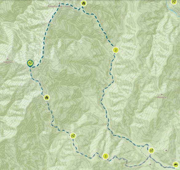
Distance: 24 km (14.9 mi)
Average Duration: 12 hrs
Difficulty Level: Intermediate
Total Elevation Gain: 1,500 m (4,921ft)
Start: Holdsworth Lodge
Finish: Holdsworth Lodge
Note: This is commonly completed as a 2-day hike. Accommodation is available at the Jumbo hut for the 1st night.
The Mount Holdsworth Jumbo Circuit is a challenging, multi-day tramp in New Zealand's Tararua Forest Park. It's a popular loop trail for hiking, camping, and backpacking
Planning
Getting There: Turn off State Highway 2 onto Norfolk Road, 2 km south of Masterton. This is signposted and there is a timber processing plant on the corner. Follow Norfolk Road 15 km to Holdsworth road end. There is a large carpark at the Mount Holdworth Road end, which services the entry to the Tararua Forest Park
Permits & Fees: There aren’t any fees or permits required.
Water: There are several huts and freshwater streams available throughout the hike.
Food: You’ll need enough food for the duration.
Accommodation
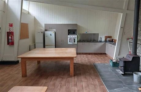
We used Holdsworth Lodge and Jumbo Hut.
Holdsworth Lodge and Jumbo hut can be booked online via the department of conservation website, on a first come first served basis.
Lodges/Huts are priced around $25-$30 per adult.
The Hike
This was the first hike we’d completed in New Zealand. There had been a big storm in the area the day we arrived. We had the whole of Holdsworth Lodge to ourselves. The storm cleared early in the evening and the night sky was a lovely treat with views of the milky way. Powell Hut has power and heating, and toilets.
As this was our first hike in New Zealand and our fitness levels weren’t at optimum level, we left at first light to make the most of daylight. Firstly, we signed the log book before leaving Holdsworth lodge. We began the trail on a gravel path, crossed a bridge and headed on an incline called gentle Annie.
There were some great views, but I was distracted by my first sight of New Zealand’s forests. I’m often intrigued by nature in other countries, sometimes it’s a tree, or plant, that I’ve never seen before, and sometimes it’s a plant I’m familiar with that grows better in a different climate. It’s fair to say we took our time taking it in. Eventually we arrived at Mountain House Shelter, a small building with some information boards. We took a snack break here for a moment and continued.
We eventually reached Powell Hut, it’s a large hut offering ample room for a rest and some shade from the sun. The hut had water but was untreated. This is an option for accommodation overnight.
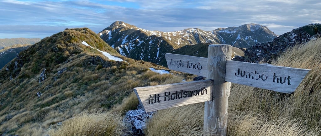
We made our way up the track which did become steep at times. There are sections of steps that can be challenging, we rested between sections of steps for a few minutes, but I did feel this was the hardest part of the hike and we considered returning several times. In time we made it to the top of the ridge which was notably exposed. The altitude made it feel a lot cooler here. Up until this point it was very well signposted, but visibility was challenging as we made our way across the ridge.
We followed the blue markers set on poles and after some time came out on a path just above Jumbo hut. I’ll never forget the wind on the small path right on the cliff edge. I hope this isn’t the correct path and we just made a mistake here. We ducked down low and moved slowly until we arrived at Jumbo Hut. There were several other people there, we talked, ate some food, and watched the sunset before resting up. The first day was challenging but rewarding.
First thing in the morning we headed back making our way through some dense bush. It was a treat to see completely different trees; it made the landscape so different. The roots of the trees are easy to trip on which I did repeatedly. I often have issues with my knees when going down and the steep tree root laden decline did cause some issues. My partners toenail came off at this point. As I mentioned we weren’t particularly fit and hadn’t hiked for several months.
We made it to Atiwhakatu Hut and pushed on. It’s worth noting there were some steep drop offs, and a little scrambling was needed here. The track had eroded in one place and was a little tricky to get around. The path runs alongside te whakaturakau stream and has a gentle gradient that was a really nice way to end the hike.
The hike can be completed by almost anyone relatively fit enough. There are challenging areas so best to leave yourself plenty of time if you’re not in good shape. We completed this hike in early summer, but I imagine the weather off season could be very challenging at the top.